As we make our passage to the Caribbean, our only long-range communications will be a Garmin InReach, which will provide text messaging capabilities (unless we get our SSB working, which seems unlikely given the time constraints). Without regular access to the internet and all the weather information that provides, I will be relying on Margaret to text me key weather information en route. In order to ensure that I get the information that I want and am familiar using, I am writing up some instructions for her and figured I would share them here. This first post is just about tropical weather forecast information that she will text me.
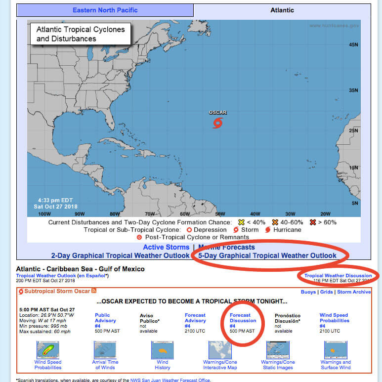
Though we are on the tail end of it, we are still in hurricane season at the moment. So I am particularly concerned about tropical weather and would like to keep an eye on it. Normally, I simply rely on the information provided by the National Hurricane Center. In particular, I regularly look at the 5-day tropical weather outlook, the tropical weather discussion, and the forecast discussion for any active tropical storms.

Where to find the five-day tropical outlook, tropical weather discussion, and depression/storm forecast discussions on the National Hurricane Center’s homepage.
Once you click through to the five-day tropical outlook, you get a graphic map of active and possible storms. There is also a handy outlook text below, which is what I am really interested in. Right now there is nothing brewing. But if a depression or worse has a possibility of forming in the next five days, the outlook text will provide a brief discussion of conditions, location, and possible formation chance. In particular, I would like Margaret to send me the location information and possible formation chance. This will allow us to plot these storms on the boat and, if necessary, ask for more information (like a look at the GFS and ECMWF long-range models).

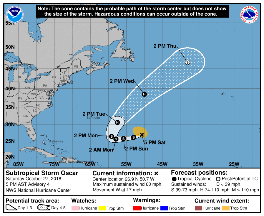
The classic cone image forecast for Sub-Tropical Storm Oscar. It is nice to see this one heading NE shortly.
The tropical weather discussion is completely text based. The parts that interest me the most – and that I would like Margaret to provide – are the tropical waves and the information about the Atlantic Ocean. The special features section does not usually contain anything but named storms or depressions, though if there is another special feature, it would be important to know. The tropical waves are listed individually:
An Atlantic tropical wave has an axis extending along 49W from
03N-14N, moving west at 10-15 kt. Scattered showers are noted
along the northern portion of the wave mainly north of 10N. TPW
satellite imagery shows this wave embedded in a region of deep
layer moisture. This feature is also depicted in tropical wave
model diagnostics.
And of that, I really just need the location and speed information of it. This will allow us to track any tropical waves, which are often – though less so at this time of year – what develops into tropical depressions and storms. They often carry associated thunderstorm activity. If a wave is close to our location, it would also be great if Margaret would share the specific information about the intensity and location of the precipitation. So, a text about the above wave might look something like this in just 87 characters:
Wave along 49W from 3N-14N. Moving west 10-15kt.
Scattered showers mainly north of 10N.
The forecast discussion for any named storm, like the one here for Oscar (not sure if the link will still be active in the future), usually contain some summary information along with details about the latest sources of information. For instance, here they say that
Earlier AMSU sounding data indicated that the cyclone has developed
a weak but vertically deep warm core which also indicates that Oscar
is nearly a tropical cyclone, if it isn't one already.
These bits of insight are not really too important to me. After that summary info, the discussion moves to an intensity forecast. Being at sea, I am planning on being a long way from any tropical weather, so I hope to not be concerned about the intensity material either. Finally, the discussion comes around to what does really concern me: the location and track information. Margaret will send me the location data at the bottom of the discussion:
FORECAST POSITIONS AND MAX WINDS

INIT 27/2100Z 26.9N 50.7W 50 KT 60 MPH
 12H 28/0600Z 26.1N 53.0W 50 KT 60 MPH...TROPICAL CYCLONE
 24H 28/1800Z 25.7N 55.8W 55 KT 65 MPH
 36H 29/0600Z 25.6N 57.9W 55 KT 65 MPH
 48H 29/1800Z 26.4N 59.1W 60 KT 70 MPH
 72H 30/1800Z 30.6N 57.5W 70 KT 80 MPH
 96H 31/1800Z 38.5N 50.0W 70 KT 80 MPH
120H 01/1800Z 46.5N 38.0W 60 KT 70 MPH...POST-TROP/EXTRATROP
Margaret can just distill it for me like this in 145 characters:
INIT 27/2100 26.9N 50.7W. 12H 26.1N 53.0W. 24H 25.7N 55.8W.
36H 35.6N 57.9W. 48H 26.4N 59.1W. 72H 30.6N 57.5W. 96H 38.5N 50.0W.
120H 46.5N 38.0W.
Typically, I really geek out over the points about the differences between forecast models, because they hint at the reliability and possible alternative tracks and intensities for the storm. There was a better discussion in the earlier Oscar forecast about significant discrepancies in the tracks provided by the major models, but now the models have come into better alignment:
The latest runs of the typically reliable global models are in
better agreement than they were this morning.
And a bit later, they clarify the outcome of the alignment of the models for the official NHC forecast:
The official track forecast has been adjusted westward to
bring it closer to the latest track consensus, especially for the
first 72 h of the forecast.
If the storm is at all tracking in our direction, I am hoping that Margaret can give me these pieces of wisdom as well.
So what weather information would you want sent to you in 160 character texts while at sea?

Confused, we thought “we” was you and Margaret. Now Margaret is your land based weather router.
Donna and I also are planning to head south next year and after reading your blog, she is convinced I could never comprehend what you have discussed. I wonder what Columbus did🤨
My use of we is a little confusing. Sorry. I am going to be bringing the boat south with my buddy, Felipe. He’ll join us this Friday. Margaret is bopping in and out, and will be leaving the boat Thursday to present at a conference and do some other photo stuff. Then she’ll meet me in the Virgins, and Felipe will return home. Got all that?
Got it. I will be paying close attention. You going east then straight to the Virgins?